Skip to content

How Recent Heavy Rains Caused This Wastewater Spill

On Friday, February 7, 2020, Charlotte Water crews responded to a broken wastewater pipe off of the Stewart Creek Greenway near 1721 Lela Avenue.

Elevated rain levels and flooding from the inclement weather the day before caused part of the creek bank of Stewart Creek to wash away, undermining the wastewater pipe. An estimated 2,163,000 gallons reached Stewart Creek in the Catawba River Watershed.
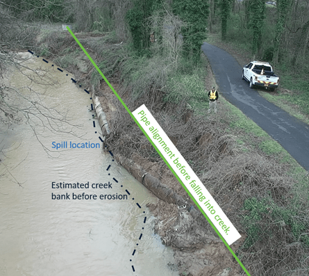
birds-eye view of muddy creek and broken section of old metal wastewater pipe along the creek bank is revealed by roadway erosion; a white pick up truck is parked on the road and 1 utility technician in yellow safety vest stand above the creek embankment; on the photo a green line is drawn along the length of the bank of the creek with a green font words Pipe Alignment Before Falling Into Creek appear in a white field, blue font appears next to the broken section, Split Location; and black font Estimated Creek Bank Before Erosion appears on the creek waters next to a black dotted line that runs the length of the photo
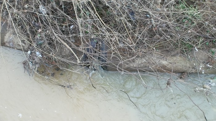
partially visible under weeds is a broken joint between 2 steel wastewater pipes as they lay revealed by the erosion of dirt along the bank of a muddy stream
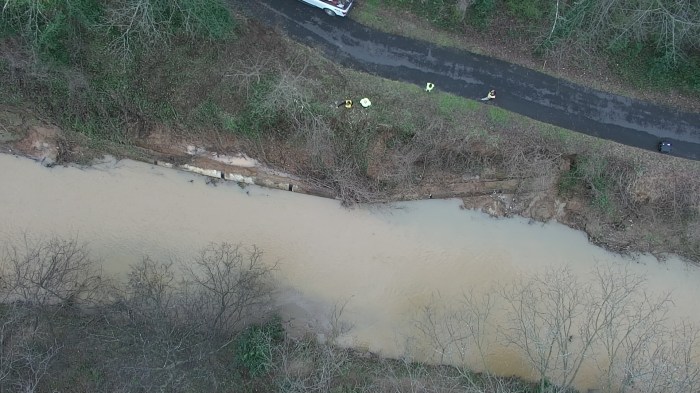
birds-eye view of a muddy stream as it passes by a paved roadway in a wooded area
Heavy rains on February 6, 2020 washed away the stream bank beside Stewart Creek Greenway, causing the wastewater pipe to fall into the creek, and separate at the joints.

Crews set up temporary pipes and multiple pumps to divert the community’s wastewater around the broken pipe to a manhole downstream. This incident did not impact our drinking water quality and no service interruptions occurred. Residents and their pets were encouraged to avoid contact with Stewart Creek.

Greenway Closed

For the safety of the public, Mecklenburg County crews closed Stewart Creek Greenway during repairs.
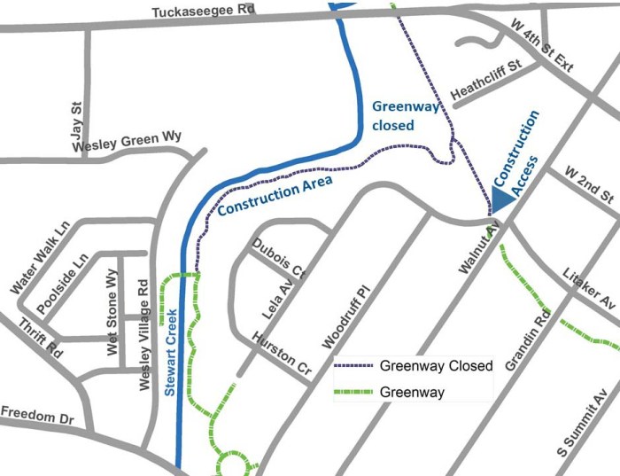
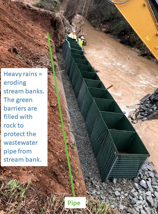
Diagram on white background of a map displaying roadways with grey lines, waterway with blue line, and construction areas with dark blue dotted lines including blue font and arrows indicating construction areas, closures, and access. The map is untitled.
Greenway closure map updated on February 25, 2020
alongside a dirt embankment and a stream of roiling waters, 2 utility technicians working with yellow excavator fill up the row of empty green box barriers set in place to block the old steel pipe half buried in a trench from the natural stream water roaring by; a white block on the photo with blue font says: Heavy Rains equals eroding stream banks. The green barriers are filled with rock to protect the wastewater pipeline from the stream bank; a green line drawn on the photo is indicated by the word, Pipe

Next Steps

With additional rain in the forecast, crews will continuously monitor this area to reduce the risk of additional overflows. Heavy equipment will be delivered to the area near the intersection of Walnut Avenue and Lela Avenue.

Crews are also working upstream near Tuckaseegee Road to enhance a stream bank that eroded and could potentially damage wastewater pipe.
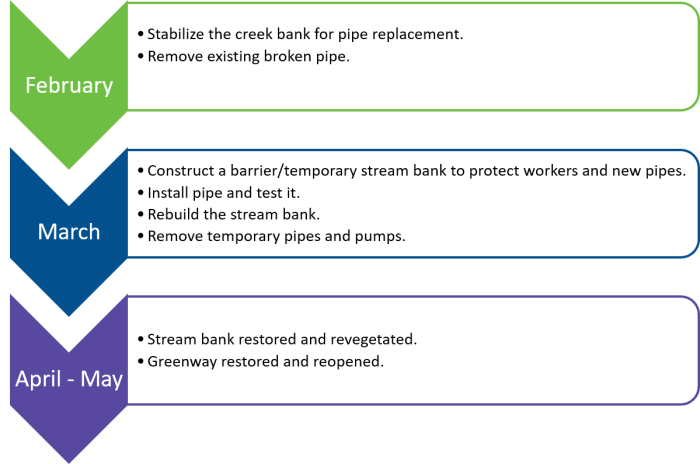
untitled chart on transparent background with 3 downward facing arrows. Each has a rectangular field to its right with bulleted info. Arrow 1- Green - February> Stabilize the creek bank for pipe replacemtn; Remove existing broken pipe; Arrow 2 - blue - March - Construct a barrier, temporary stream bank to protect workers and new pipes install pipe and test it, rebuild stream bank, Arrow 3 - purple - April to May - Streambank restored and revegetated, Greenway restored and re-opened
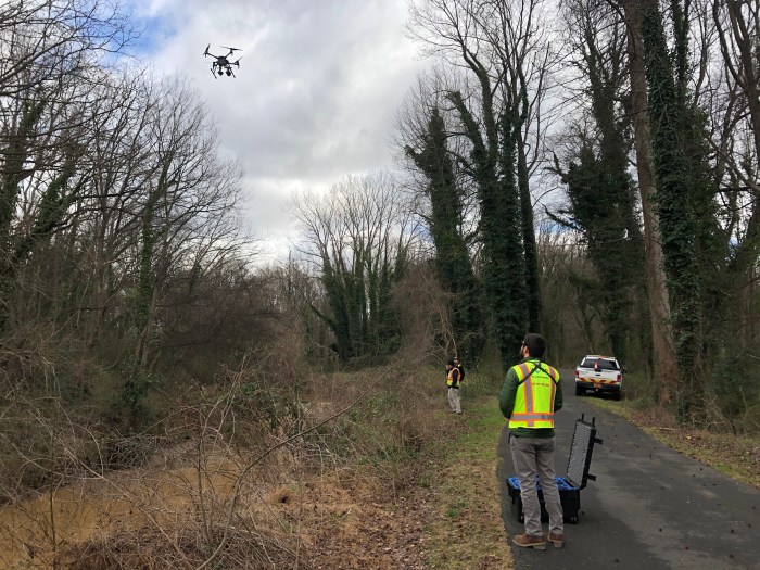
standing along a wood-lined roadway next to a creek, 2 utility technicians wearing yellow safety vests stand near a white pick up truck and large black trunk as they look up a drone in the sky
2 hands operate a black video recording ipad type unit with 2 joy sticks, on the monitor is an image of a broken pipe along a stream along with various icons indicating aspects of what is on the screen
Charlotte Water flew a drone over the spill location to analyze the pipe damage and stream bank erosion.

Questions and Answers:

How does CLTWater handle heavy rains and prevent spills?

The underground sanitary sewer pipe network is not designed to handle rain, yet the runoff and flooding from large rains inevitably infiltrate the wastewater pipe network. Overflow basins at the five largest wastewater treatment plants capture and later treat more than 100 million gallons of rainwater mixed with wastewater. Throughout the storm, all plants operated well and no spills occurred at any Charlotte Water plant. These equalization basins (EQ basin) help prevent wastewater from overflowing out of manholes in our community.

CLTWater has also added several large wastewater pipes to help reduce the impact of heavy rains. Crews work to prevent rainwater from getting into the sanitary sewer system and are out investigating our system soon after a storm ends.

What is the largest wastewater spill in CLTWater history?

The three largest spills were all caused by heavy storms eroding creek banks causing pipe collapse.

  1. April 15, 2018, into Long Creek spill (15.4 million gallons).
  2. October 25, 2017, into Mallard Creek (4.8 million gallons).
  3. May 22, 2003, into McAlpine Creek (4.752 million gallons).

Charlotte Water continues to drive down the number of wastewater spills each year. In 2019, Charlotte Water collected and treated 99.99% of the community’s wastewater.

Have a question you’d like to ask? Feel free to contact us: ccoley@charlottenc.gov

Discover more from Charlotte Water Blog

Subscribe now to keep reading and get access to the full archive.

Continue reading

document.addEventListener('DOMContentLoaded', function () { const observer = new MutationObserver(() => { document.querySelectorAll('.jetpack-instant-search__search-result-expanded__image').forEach(img => { if (!img.hasAttribute('alt')) { img.setAttribute('alt', ''); } }); }); observer.observe(document.body, { childList: true, subtree: true }); });